

The Suwanee Dam Road Annexation: A Deep Dive into Zoning, Planning, and Community Impact
A proposed annexation & rezoning near Suwanee Dam & Hwy 20 could bring a vibrant retail and recreation hub to Sugar Hill. This article explores in detail the process of decision making on rezonings.

Annexations and rezonings are typically the most controversial decisions that come before City Council. Carefully weighing private property rights against the desires of the community is a delicate balance in which both sides must give in order to find compromise.
From my personal perspective, I’m a very strong believer in private property rights. If an individual has a reasonable proposed use for their property that’s not already permitted under the property’s current zoning, that should be respected and permitted. What’s reasonable? This article will go into great detail how I define and determine reasonable.
Some context about this article. It is long but I hope it provides important insight not just to this particular annexation and rezoning case but to how I approach a decision on City Council. If you’re not overly familiar with the annexation and rezoning process, my hope is that this article will provide a detailed explanation of it. While I would like to discuss each rezoning at this level of detail, Georgia’s Zoning Procedures Law and related case law caution elected officials against making public statements or commitments prior to the official public hearing, to ensure compliance with due process and avoid the appearance of bias.
Since the official public hearing for this project was held on June 9th, 2025 and the zoning was tabled, it offers this opportunity to discuss how I approach an active zoning case in greater detail.
Balancing Private Property Rights vs Community Desires
All property has an underlying zoning. Meaning, all property is entitled to a permitted use without any decision by the local municipality. This is an important consideration when a new zoning is proposed for property. Here are the questions that I contemplate for every rezoning:
Is the proposed zoning substantially different than the underlying zoning?
Is the proposed zoning substantially different than the surrounding zonings?
Is the proposed zoning in conformance with the city’s master plan?
Is the proposed use out of character with the existing uses within the same vicinity of the proposed zoning?
These are the most important questions I consider to find balance with private property rights and community desires.
In June, a proposed annexation and rezoning of property near the intersection of Suwanee Dam Road and Highway 20 came before City Council. You can watch the discussion from that meeting below starting at the 41 minute mark. It’s a good listen if you have the time - either before or after you read this article.
The proposed use is a commercial retail and restaurant center. Below is a map with the parcels for the project outlined in red. Blue indicates property already within the city limits. White indicates property within unincorporated Gwinnett County.

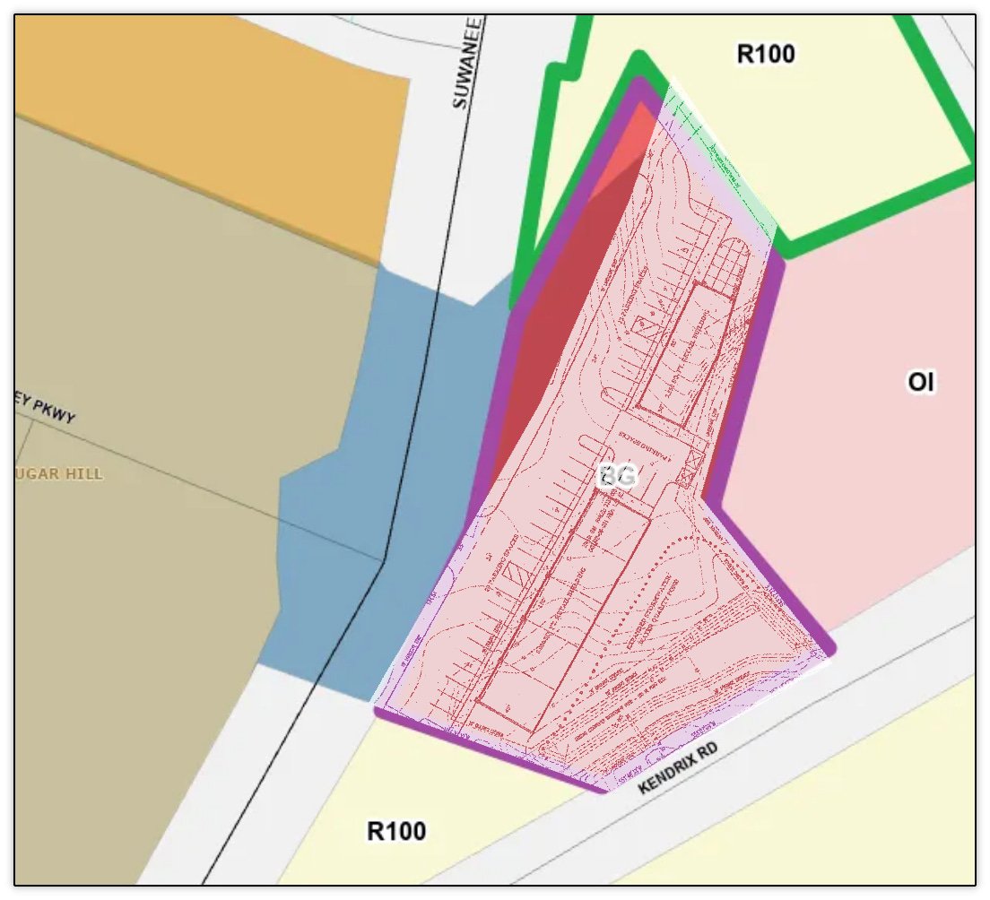
As previously mentioned, the parcels already have an underlying permitted use. Below is a map of the existing zonings. Approximately 2/3 of the proposed project is already zoned BG (General Business) within the city limits, which is outlined in purple. Approximately 1/3 of the proposed project is zoned R-100 and lies within unincorporated Gwinnett County.

Here’s the city’s definition of what the BG zoning is intended to be from the city’s zoning ordinance.

The applicant is requesting that the green outlined property above be annexed into the City of Sugar Hill and rezoned to BG for a retail and restaurant use. The purple outline is already zoned for that use - meaning without any action by City Council, the property owner could build a retail and restaurant use on it today.
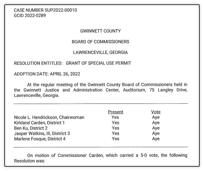
That property was annexed and rezoned to BG in March 2008 by City Council and approved by then Mayor Gary Pirkle.


Here are the minutes from the meeting where the property was annexed and rezoned from the county’s O-I (office and institutional) to the city’s BG.

The existing BG zoned property along with an adjoining parcel was previously rezoned from R-100 to O-I in the county in February 1998, so that the existing daycare, Discovery Point Sugar Hill, could be built.
That brings us to the current proposed rezoning of the two parcels currently zoned R-100. R-100 zoning within the county is one of the most common residential zonings in the county.
Answering the Questions
The proposed rezoning would annex the two parcels into the city and rezone them to BG. Let’s answer the four questions from above.
1. Is the proposed zoning substantially different than the underlying zoning?
Yes - it’s fair to say that the proposed zoning of BG (commercial) is substantially different than the underlying zoning of R-100 (residential). Since the answer to that question is yes, that gives pause. That means that the answers to the next three questions are vitally important.
2. Is the proposed zoning substantially different than the adjacent zonings?
No - the adjacent zonings that touch the property are all commercial uses. Let’s go back to the map. Remember that the only property being rezoned is the property outlined in green.
The properties across Henry Bailey Road are also all zoned commercial - C1 or C2 in unincorporated Gwinnett County. The property across Suwanee Dam Road is zoned R-TH (townhomes) in unincorporated Gwinnett County. R-TH is generally viewed as an appropriate transitional use between less dense residential zonings and commercially zoned property.
The properties directly touching this property are zoned O-I and BG (both commercial), including a parcel zoned exactly the same as what is being requested.
3. Is the proposed zoning in conformance with the city’s master plan?
The city has two plans that apply to this property. These plans are community driven desires for how our citizens would like to see the city develop and grow. The first is Envision100 - the city’s most current comprehensive plan that was adopted last year. Since the property lies outside the city, it wasn’t included in our city’s comprehensive plan.
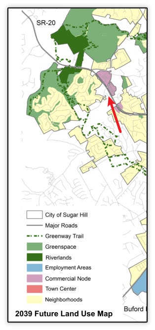
In fact, most of the property in this area lies in unincorporated Gwinnett County. Below is a map showing the surrounding parcels. Unincorporated Gwinnett County is white and city is blue. Red arrows point to the subject parcels. The parcels outlined in yellow were annexed and rezoned to RS-72 (residential) into the city in May.
Despite it not being within the city, the property at the intersection of Highway 20 and Suwanee Dam Road is within an area of a “commercial node” character area. Had this property been within the city, it is reasonable to see this property being included within that commercial node given the surrounding uses. Here’s what Envision100 sees within commercial nodes.

Further evidence is that the majority of the parcel is already zoned BG and the property requested to be rezoned is between the existing BG parcel and parcels already zoned commercial.
The city also has a second plan called Aspire Hwy 20. This corridor study was done in 2018 to solicit the community’s input on the major transportation corridor that bisects our city. Since the corridor contains significant portions within the city and outside the city, this plan was put in place to guide both city and county development to hopefully find a cohesive plan between the two local municipalities.
Here is this node from the plan.

The yellow arrow points to the proposed project and lies within the deep purple, which the study classifies as “High Density Mixed Use”.

Next is to see how the study defines “High Density Mixed Use.”

And what are the specific uses the plan sees for this? Highlighted in yellow is the proposed use on the y-axis and the land use characteristics on the x-axis.

According to the Aspire Hwy 20 plan, the proposed use of retail is a “yes” for the “High Density Mixed Use” land use.
The answer to this question is clearly “yes” - it is in conformance with the city’s plans for this property.
4. Is the proposed use out of character with the existing uses within the same vicinity of the proposed zoning?
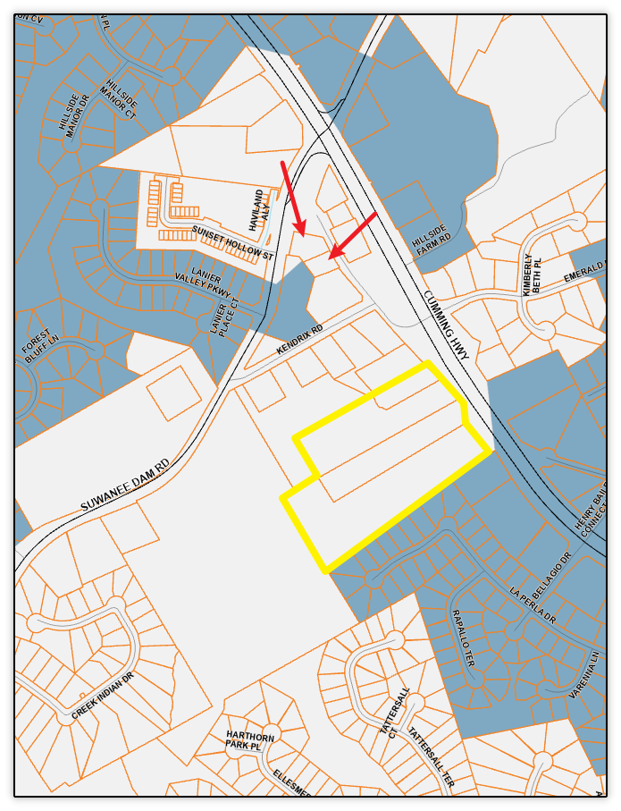
This question, while similar to question 2, pulls back farther to look at the zonings and uses that are in the larger vicinity of the project so that we can see in context a bigger picture. For that, we go back to the map showing both city and county zonings in a larger context. Red is commercial zoning, regardless of city or county zoning. Red arrow points to the subject parcels.

In context of even a larger picture, the answer to this question is clearly no - the proposed zoning is not out of character of the existing uses within the same vicinity.
So, we’ve established that while the requested rezoning differs significantly from its underlying zoning, it’s completely in character for the surrounding zonings, city planning documents and uses within the vicinity of the project. That leads to a very strong case that the requested zoning is completely reasonable.
Analyzing the Specifics of This Case
The request is specifically to build a retail and restaurant project with some sort of recreational amenity as the center point of the project.

The overall concept is interesting - a central courtyard with a proposed wave runner style recreation with outdoor dining and retail surrounding it.
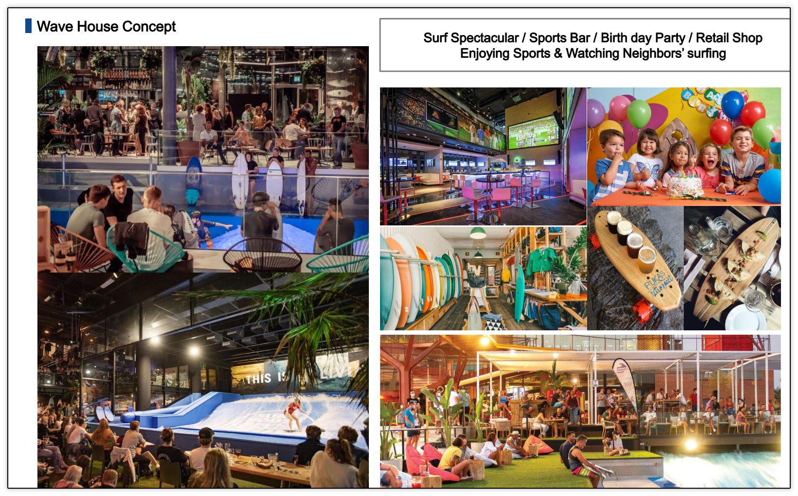
The applicant in the public hearing suggested that it could be some other recreational use besides the wave runner but the intent was the recreational component be the central gathering and focal point of the project.
The concept is something different for this area by creating a central gathering point rather than traditional strip retail development like what we see in surrounding commercial uses at the Kroger retail/restaurant area, the Publix retail/restaurant project and the Bellagio retail/restaurant project in front of the Ashford Crossing subdivision. It meets more the intent of the Aspire Hwy 20 plan and the overall BG zoning definition.
What Happens if the Annexation and Rezoning are Denied?
Let’s go back to the ask first so it’s clear what exactly would be denied.
Here is the same map with the buildings and parking overlayed onto the parcels.

The ask is for the outlined green portion above, where most of the buildings are located, to be commercial. This places the buildings closest to the other commercial zonings and buildings and farther away from the residential zoned property within the vicinity.
Denial would allow for commercial to only be built on the existing red portion since it’s already zoned for that. Let’s overlay what was proposed and approved in 2008 on the same plan, just zoomed in on the existing BG zoned property.
This would allow for two entrances (rather than the proposed one entrance) on Suwanee Dam Road in a traditional strip retail fashion pushing the buildings closer to the residential property. It also removes the central recreation component that makes the proposed use more interesting. It does not prevent the project from connecting to Henry Bailey Road since the applicant already owns the residential zoned (green outline) property. He could simply build a connecting driveway through the residentially zoned property to the commercial property.
The residentially zoned property would remain in unincorporated Gwinnett County. The applicant would likely request the property to be rezoned to commercial in Gwinnett County and it almost certainly would be approved. The county allowed for the construction of a car wash at the intersection of Suwanee Dam Road and Hwy 20 over the city’s objections to the use in 2022 and is under construction now.
Here’s the approved plan and vote by the Gwinnett County Board of Commissioners for the car wash.

Here was the city’s objection letter regarding the car wash. However, as the property lies within unincorporated Gwinnett County, it was ultimately the county’s decision and they approved it.
We can expect that this property will be zoned by Gwinnett County for C1 and possibly C2 for a commercial use - likely strip retail, gas station or convenience store. While the city has prohibited uses like gas stations for the project (as seen below), these conditions would not apply in the county unless they chose to include them.
The project, rather than being an interesting, cohesive restaurant/retail project focused around a central recreation component will be typical suburban strip retail at best with 2/3 of it in the city and 1/3 of it in the county.
The property would be limited to only the conditions in place in 2008, which are:

These conditions, to be clear, would only apply to the existing BG zoned property. If the county rezones the property to commercial, it would be their decision as to what conditions, if any, would apply to that property.
Where I Stand and Addressing the Objections
I plan to vote to approve the annexation and zoning in July, which would not only impose the above conditions on the property, it would add the following staff recommended conditions along with some additional conditions:

I’m proposing to modify and add the following conditions, which I discussed both in the work session and at last Monday’s meeting:
No access to Kendrix Road shall be permitted.
The access to Suwanee Dam Road shall be limited to one entrance, aligned with Lanier Valley Parkway. A left turn lane from Suwanee Dam Road shall be provided into the development along with other improvements as required by Gwinnett County Department of Transportation.
Prior to issuance of a Land Disturbance Permit, a Level 2 traffic study with Intersection Control Evaluation (ICE) shall be provided which explores safe ingress-egress options for the development, including analysis of the entrance from Suwanee Dam Road into the development and the intersection of Henry Bailey Road and Georgia Highway 20. Should a signal be warranted as a result of the proposed development, developer shall contribute $50,000 towards the construction of a signal at the intersection. (REPLACE CONDITION 5)
Two City Councilmembers have already signaled their intent to vote against this, which would be a poor outcome for the city and the surrounding residents. The objections expressed by those indicating voting against were largely the same as public comments, can be heard in their entirety in the video above. Some expressed concerns, like loud engines on Highway 20 on Saturday nights, are not applicable to this project. Summarizing the concerns that apply to the project are:
Objection to access to Henry Bailey Road. The project could still connect to Henry Bailey Road even if denied since the applicant owns all the parcels. The owner can build a drive across the property to access Henry Bailey Road. If/when the county rezones the R-100 zoned property to commercial, those parcels will have to access Henry Bailey while possibly building yet a third entrance to Suwanee Dam Road since the properties front on both roads and there is an existing driveway connection to Suwanee Dam Road. Approval solves all of this now by limiting access to one entrance on Suwanee Dam Road and one entrance on Henry Bailey Road and no access to Kendrix Road.
Objection due to the current configuration of Henry Bailey Road at Highway 20. This project, through the proposed conditions, gets the community closer to the desired outcome of a traffic light at Henry Bailey Road/Emerald Parkway and Highway 20. In addition, I’ve been working with Georgia DOT, Gwinnett DOT and city staff to make immediate improvements at that intersection, including building an island at the right turn out of Emerald Lake subdivision and adding striping and lane delineators to the intersection. Once again, denial doesn’t alleviate this problem because the property can still be rezoned and developed in the county. My proposed condition 3 deals with this concern as well.
Objection because of a right in/right out only entrance on Suwanee Dam Road and no place to make a U-turn into the property from Suwanee Dam Road. I oppose a right in/right out entrance on Suwanee Dam Road for a number of reasons which is why I’ve proposed condition 2 to address this. Not only that, a right in/right out would push more traffic to make a left from Suwanee Dam Road on to Kendrix Road. Kendrix Road is a substandard road that has sight distance issues due a substandard vertical curve on it and it’s not really wide enough for even two normal sized cars, let alone larger trucks. Denial of this project will increase the use of Kendrix Road in the likely event the R-100 zoned properties are zoned commercial in the county. These parcels would be disconnected from this project since customers coming from Suwanee Dam Road will use Kendrix Road to access the parcels off Henry Bailey Road rather than going through the intersection of Highway 20 and Suwanee Dam Road to make a right on Henry Bailey Road.
Objection to “adding cars to Highway 20” from the proposed project. The issue with this is that this property is going to be developed and is already approved for commercial zoning. Denying this doesn’t change that and only pushes the commercial zonings to be even more disconnected and auto oriented without a requirement to actually study what is going on at the intersections.
Part of being a Strong Community is looking deep into every decision that comes before City Council and looking out for the long term best outcomes and bigger picture. Bigger than the understandable emotional reaction of not wanting change. Understanding that the place you live now (unless you’re living in the same place you were born, including the same house) grew, developed and changed to accommodate you. The opposite, stagnation or decline, is certainly not a Strong Community. Supporting development that devalues over time, like traditional strip and big box retail, also doesn’t support a Strong Community. Supporting quality growth that builds connection and diversifies the city’s residential and commercial base built by local developers is how you get a Strong Community.
Have thoughts or questions about this proposal? I welcome your feedback ahead of the July vote.