

Looking back to the 2005 Town Center Master Plan
The first step in the journey of the (re)birth of downtown Sugar Hill.

According to the 2005 Town Center Master Plan, the city began the process of developing a master plan for downtown in March 2003. The city would award the contract for the plan in 2004 and adopt the plan in 2005.
This plan set the stage for what would become downtown Sugar Hill, now 20 years later.
Let’s review the goals and objectives from that plan, which can be downloaded here.
The plan (page 5) called for 8 specific goals that were identified by the city:
Provide a mixture of affordable housing that meets the needs represented in the Market Assessments.
Provide a mixture of retail/office space, dining, as well as family entertainment establishments to meet the needs of the existing and future population within the city.
Use available land efficiently through mixed use developments.
Create a set of standards and overlay districts that protect and enhance existing land within the Study Area as well as encouraging new development to fall within the design standards to create livable places.
Create short, intermediate, and long term work projects that enhance the intermodal connectivity of the Study Area.
Maintain and enhance pedestrian linkages between all uses within the Study Area.
Increase pedestrian consideration and safety.
Enhance the city’s aesthetic infrastructure.
Looking back on the goals, which are admirable, it’s fair to say they’ve been largely realized.
Goal 1 has been, without a doubt, the most difficult to achieve. The free market largely dictates housing costs. However, the currently under-construction developments within the Town Center Overlay area represent the best opportunity for more affordable housing types.
Goal 2 has largely been met with more on the way. The E Center, the Eagle Theatre, the Bowl and the Dawn P Gober Community Plaza provide numerous opportunities for family entertainment. The mix of restaurants is getting better in downtown and now that the Solis development is nearing completion, the restaurant and retail combinations will continue to improve. Office space is in demand in the downtown area, with more scheduled to be built in the coming years such as the Northside Hospital medical complex zoned at the corner of Sycamore Road and Highway 20.
Goal 3 has also largely been achieved with mixed-use developments like The Local, Solis and the E Center.
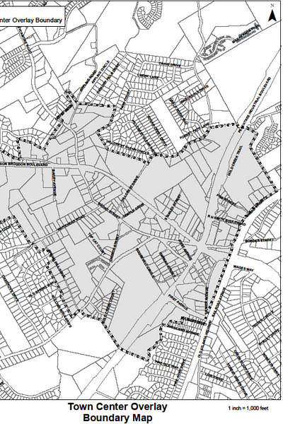
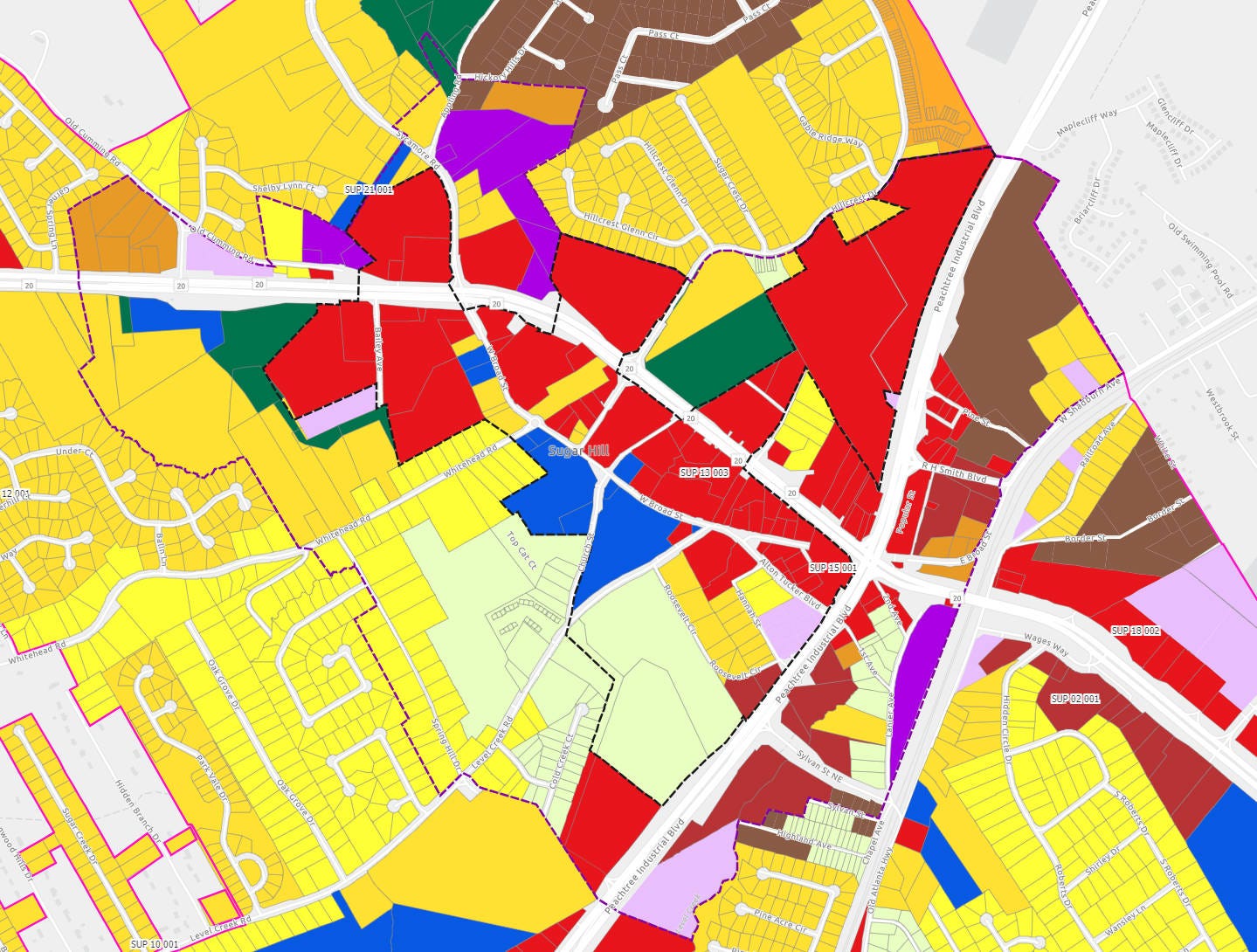
Goal 4 led to the two overlay districts in downtown - the Central Business District and Town Center Overlay. Attached is the current portion of the city’s zoning ordinance for those two districts and below is the current map of those two areas. The Central Business District, which is the core downtown area, lies entirely within the Town Center Overlay.
Goals 5, 6 and 7 are connected and deal with connectivity, transportation and, most importantly, pedestrian connection within downtown and the Town Center Overlay area. The addition of the Greenway, which was not contemplated in 2005, has been a critical addition in meeting these goals, expanding pedestrian access outside even the Town Center Overlay area. The expansion of the greenway north of Highway 20 along Stanley Street provides critical pedestrian connections to existing and future residents between Peachtree Industrial Boulevard and Hillcrest Drive. The currently under design pedestrian bridge which will connect the north and south sections of the Greenway will be a critical piece of infrastructure to provide safety to pedestrians crossing Highway 20 in the downtown area and limit disruption to Highway 20 from on-grade pedestrian crossings. Interestingly, the 2005 plan recognized the need for a grade separated pedestrian crossing due to the future widening of Highway 20. It also included the now nearly complete intersection of Alton Tucker Road/Level Creek Road with Stanley Street at Highway 20.

In fact, the early draft included two pedestrian tunnels. (Sugar Hill Church known as Sugar Hill Life Church at the time.)

Goal 8 was not well defined in the plan, but the enhancements to the city’s parks, including downtown parks like the Veterans’ Memorial, Cornerstone Park, the Bowl, the Landing, the E Center, City Hall campus, the Dawn P Gober Community Plaza, 39th Street Station and the Historic Cemetry, among others, all have high aesthetic value. The addition of a city history museum and art gallery also contribute significantly to the aesthetic infrastructure, as will the future pedestrian bridge.
The plan recognized that if the goals were realized, these three objectives could be met:
Increased economic diversity and employment opportunities for several employment sectors.
Improve stability of the city’s tax base in order to facilitate city, county and school expansions and upgrades.
Improve position and image in Gwinnett County, leading to more economic development opportunities in the future.
While downtown is currently in the awkward teenager phase of its growth, these objectives have already been met. The restaurants, professional services, medical services, health and fitness services, insurance services, personal services and other employers have provided a mix of employment opportunities meeting objective 1. Undoubtably, objective 2 has been met. This point will be explored on more detail in a future article, but The Local alone, which sits on just 7.5 acres, contributes more tax revenue to the county and school system than the entirety of Sugarloaf Mills Mall, which sits on over 112 acres. Finally, objective 3 has absolutely been met. The 2005 plan acknowledged something very important - the lack of a strong sense of place or identity. It was simply a bedroom community in the suburbs of Atlanta.

The site plan portion of the master plan called for 275,000 square feet of mixed-use, retail and office. It included 90 townhomes with 30,000 to 60,000 square feet “available in upper floors of mixed use buildings” - presumably for residential or office but the plan was not specific. It also included 850 parking spaces, which appears to include the surface parking and proposed parking deck. The plan also called for an “activity center” and realignment of Alton Tucker Boulevard, Level Creek Road and West Broad Street with a roundabout and, as previously mentioned, connection to Highway 20. It showed a new city hall location, amenity pond and called for commercial anchors at either end of downtown.
While the site plan is only a portion of the master plan, how does it compare to today? It’s pretty clear that much of the plan has been realized - city hall, city park and regional detention pond are nearly as depicted, of course, without the amphitheater. The activity center is today the E Center. The parking deck exists next to city hall, although an additional parking deck has been built opposite city hall in the Solis mixed-use development. Interestingly, Temple Drive was removed in its entirety in this plan. The roundabout exists at Whitehead Road and West Broad Street.
As you read the 2005 Town Center Master Plan, keep in mind the economic conditions of the mid-2000s - a historic and unsustainable development pattern was underway due to the federal government’s backing of mortgages for single-family homes and banks financing any development that walked in the door due to this backing. It would lead to one of the greatest economic collapses in United States history in the Great Recession that would unfold starting towards the end of 2007. It would also delay the implementation of the plan but would allow the city to acquire parcels within downtown at incredibly affordable prices, which will be explored in a future article.
Thankfully, the city was turning away from the typical suburban pattern prior to the collapse and setting the foundation for more sustainable and traditional growth opportunities. In particular, the 2005 Land Use Amendment, which we’ll explore next and in even greater detail in the 2008 Sugar Hill Comprehensive Plan, which we’ll cover in a future article.
To close this article, we go back to the closing paragraph of the “Overview” from the master plan, which summarizes the entire point of downtown so well:

The 2005 Town Center Master Plan was the planting of Sugar Hill’s flag that it was going to be more than a bedroom community - the residents wanted to realize its potential as a real city and find its identity, making it a Strong Community.
Thank you Taylor SO much for filling in more of the backstory for those of us who were not part of Sugar Hill in 2005.