

Gary Pirkle Park - What to do?
Gary Pirkle Park is a popular, active park in Sugar Hill. But it's constructed in floodplain and floodway meaning it presents a large, long-term financial and safety liability for the city.

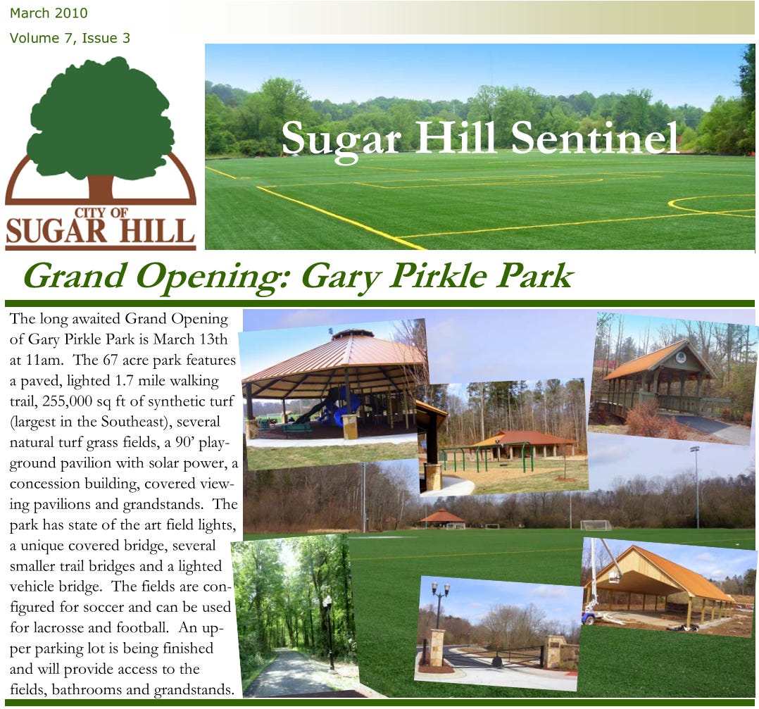
Gary Pirkle Park opened in March 2010 after the city started acquiring property for it beginning in 2004. The city would acquire parcels either through donation or purchase over the next several years in exchange for the annexation and rezoning of the Barrington Estates subdivision into the city.
Nearly all of the property that was donated to the city is, at it usually is, undevelopable property. In the case of Gary Pirkle Park, the property is made up of floodway, floodplain and an emergency overflow easement granted to the Army Corps of Engineers for Lake Lanier. In other words, property of no value to a developer.
The one property the city did purchase was the western parking lot parcel along Suwanee Dam Road. This property, consisting of approximately 5.6 acres was purchased for a rather hefty $590,000 (approximately $860,000 in 2024 dollars) from the Garner family. Of that 5.6 acres, approximately 4 acres is not in floodplain or floodway. With the exception of a small strip of property where the restrooms are located, it’s the only area in the park not in floodplain or floodway north of Austin Garner Road.
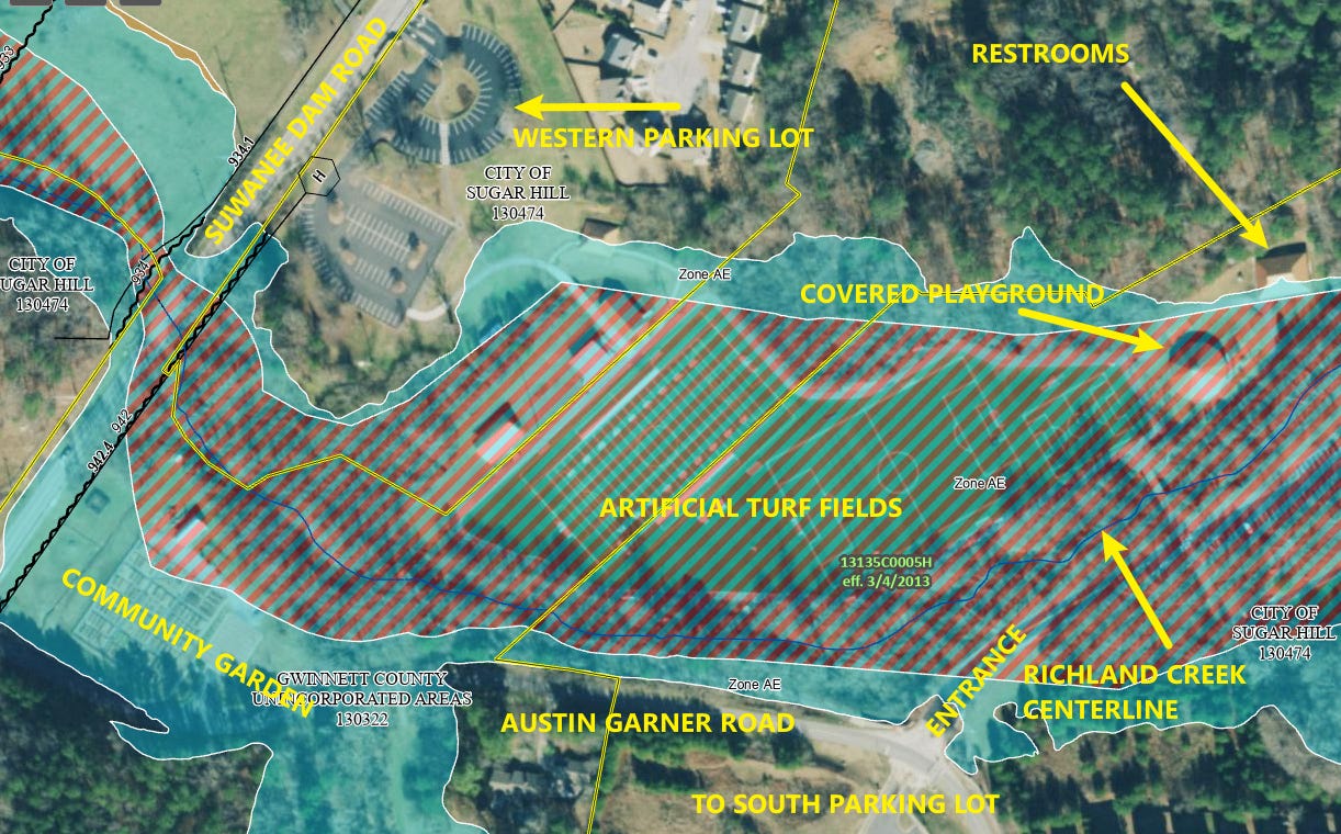

The reason for all the floodplain and floodway is that the park is bisected by Richland Creek. From Suwanee Dam Road upstream along Richland Creek to the furthest point north of the main parking lot, Richland Creek traverses over a half mile - some 2,800 feet - through the park.

The park is a popular and heavy utilized active park because of the artificial turf fields for soccer and football. In fact, at opening, the 255,000 square feet of artificial turf was heralded by the city as the largest artificial turf surface in the southeast.
As is likely self-evident at this point, building an active park with structures and artificial turf in floodway comes with a significant amount of risk.
What, exactly, is floodway and floodplain? Floodway has a specific definition from the Federal Emergency Management Agency (FEMA) but it’s basically the primary area of water movement during a flooding event. This differentiates it from floodplain in that floodplain is the area in which water inundates (or occupies but not the primary flow path) during a flooding event.
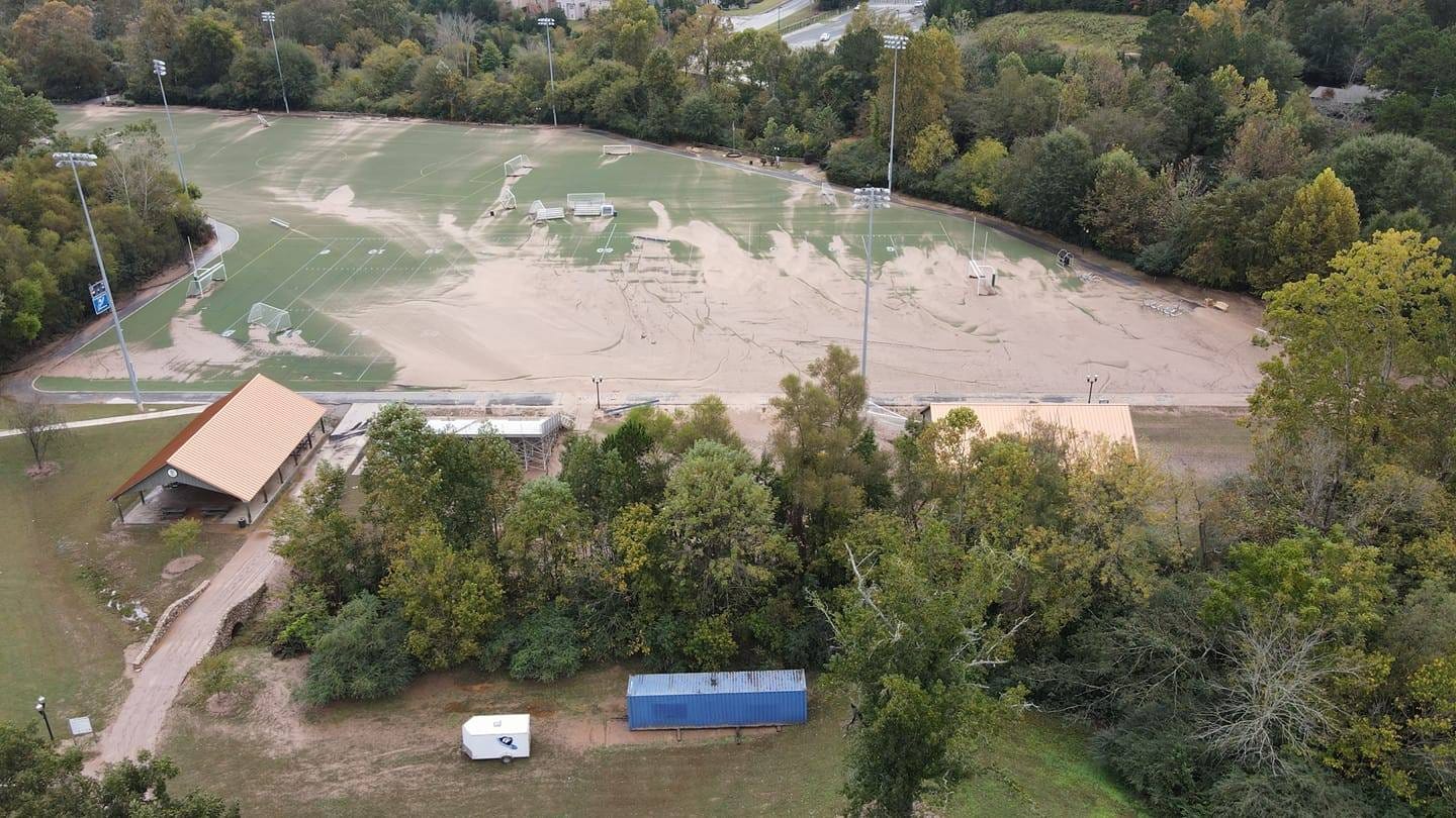
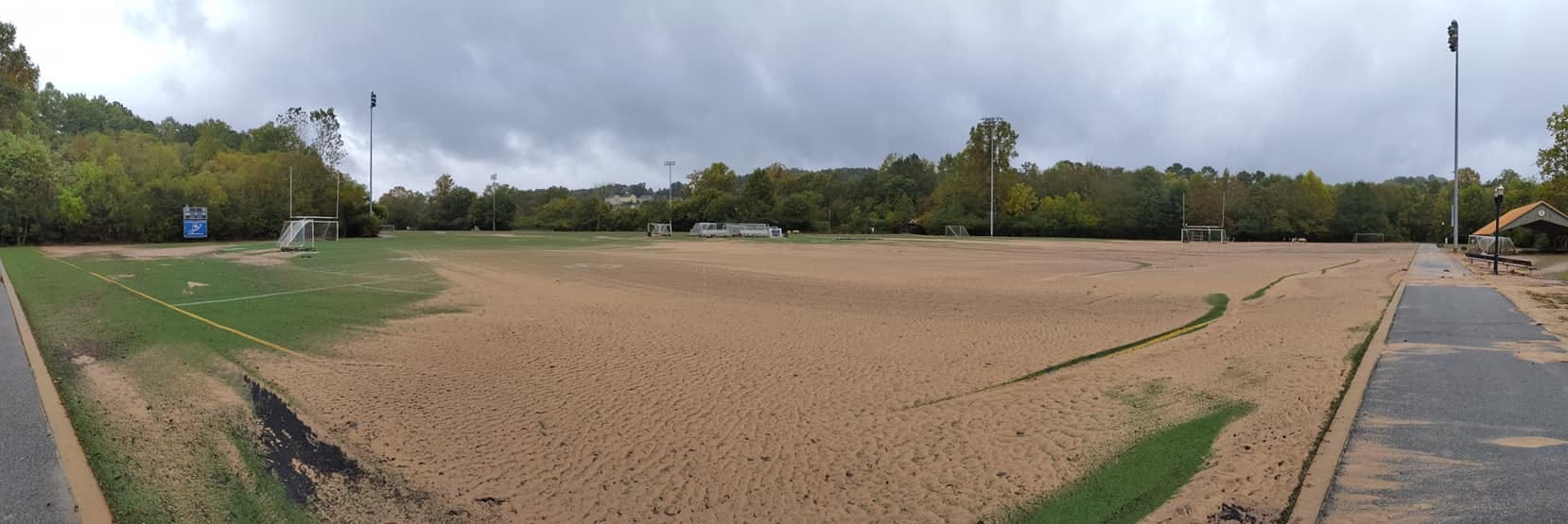
In the late hours of Saturday, October 10, 2020, the remnants of Hurricane Delta dumped around 7.5 inches of rain between 7 PM and midnight. This event caused Richland Creek to leave its banks and utilize the designated floodway, including the western artificial turf fields, dumping tons of silt and damaging structures and the asphalt walking trail. The flooding dumped tons of silt in the primary parking lot for the park as well.
This closed the park and destroyed the entire artificial turf field. Below are images from the flooding event.


As a result of the damage, City Council awarded a contract for the replacement of the artificial turf fields in December 2020 for $938,283.15. The field would be out of service until early spring 2021.

NOAA has a gauge on Richland Creek where it cross Suwanee Dam Road and in the discussion of the flooding stages discusses impacts to the fields at Gary Pirkle Park based on the depth of the creek at various flood levels.

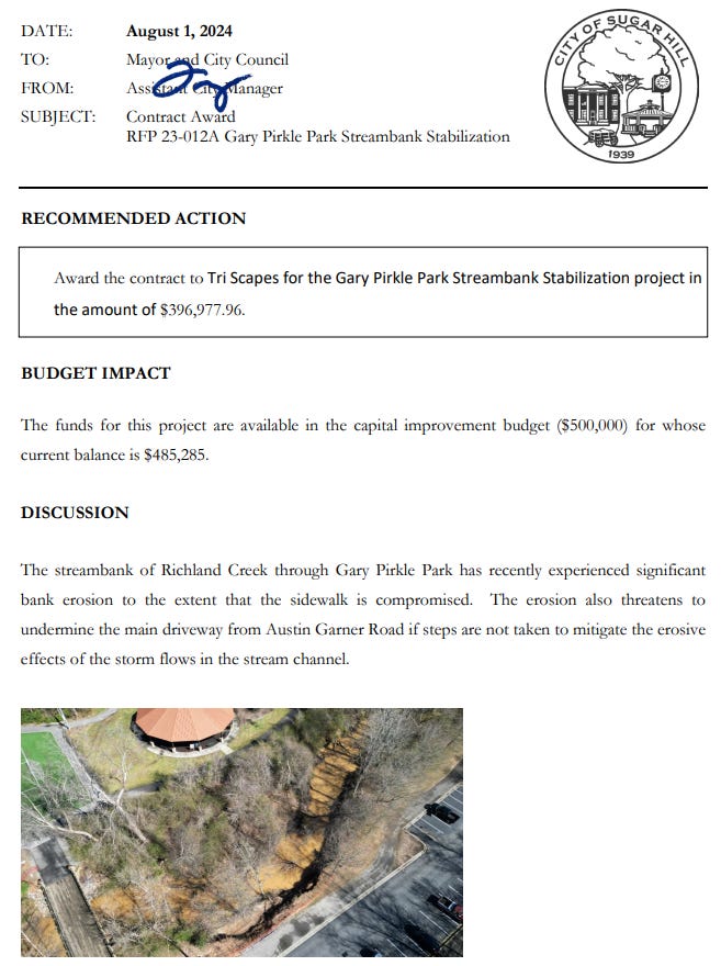
Most recently, the city will consider awarding a contract in the amount of $396,977.96 for stream bank stabilization of 300 feet of Richland Creek’s southerly bank that has eroded to the point that it’s compromised the sidewalk at its August city council meeting. That’s roughly $1,200 per foot of stream bank to stabilize a small portion of the nearly 5,600 linear feet of stream bank that abuts either the parking lot, turf fields, walking trail or community garden between Suwanee Dam Road and the northern point of the park’s main parking lot.
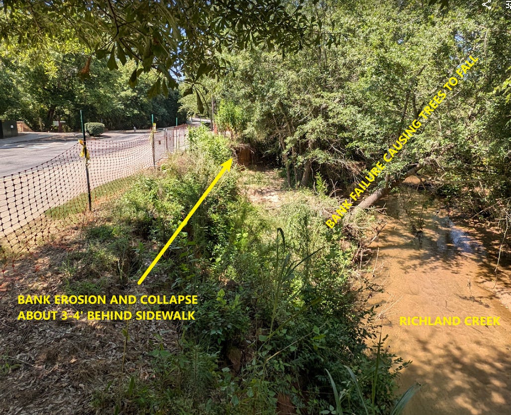
The city had already performed work to shore up a bridge crossing in early 2023 due to erosion of the abutments for a pedestrian bridge in the park.

In the aerial image below the centerline of Richland Creek is in blue and its close proximity to the built infrastructure can be seen.

Richland Creek is a very large creek with a major drainage basin associated with it. The area draining through the park is almost the entire area east of Suwanee Dam Road, south of Buford Dam Road, north of Highway 20 and west of Shadburn Avenue.

Here’s what the area looked like prior to the construction of Barrington Estates and Gary Pirkle Park in 2002.

What I believe to be the appropriate direction for the future of the park is for it to become a passive recreation park with the turf fields and most of the main parking area removed. The city should look to build a new active park with soccer, football and lacrosse fields located elsewhere in the city and not in floodway or floodplain.
A reimagined Gary Pirkle Park could be an incredible passive park that would be the eastern end of the National Park Service’s proposed Richland Creek Trail. It could contain walking trails, bike paths and continue to serve (and expand) the incredible community garden among other passive recreation that would present the financial liability the park presents currently.

This is necessary because the park, as constructed today, is a ticking financial time bomb that we don’t know when it will go off. At any time, a large rain event, most likely from a tropical storm, could once again inundate our area and flood the turf fields again.
In addition, Richland Creek will continue to move and reshape its banks as it has for millennia, requiring extensive and expensive streambank stabilization projects both now and again in the future. Streambank stabilization projects are not permanent fixes either - over time, flowing water always wins and will undermine the project that the city is about to spend $400,000 on.
Going back to 2005, when the city accepted the donation of the land from the Barrington Estates developer, then Mayor Gary Pirkle acknowledged in his remarks that the area should be used for passive recreation. The soccer fields, at the time, were going to be natural grass fields - not artificial turf. That decision was made a few years later.

To further illustrate the need to move the active fields elsewhere, there has been great demand for restrooms on the eastern artificial turf fields, so parents and kids don’t have to walk to the far north end of the park on the other side of Richland Creek to go to the restroom. The city has investigated options for adding restroom facilities to the eastern side, however, both permitting and cost issues have kept the city from adding the restrooms because the property is entirely in floodplain where structures can’t be built.
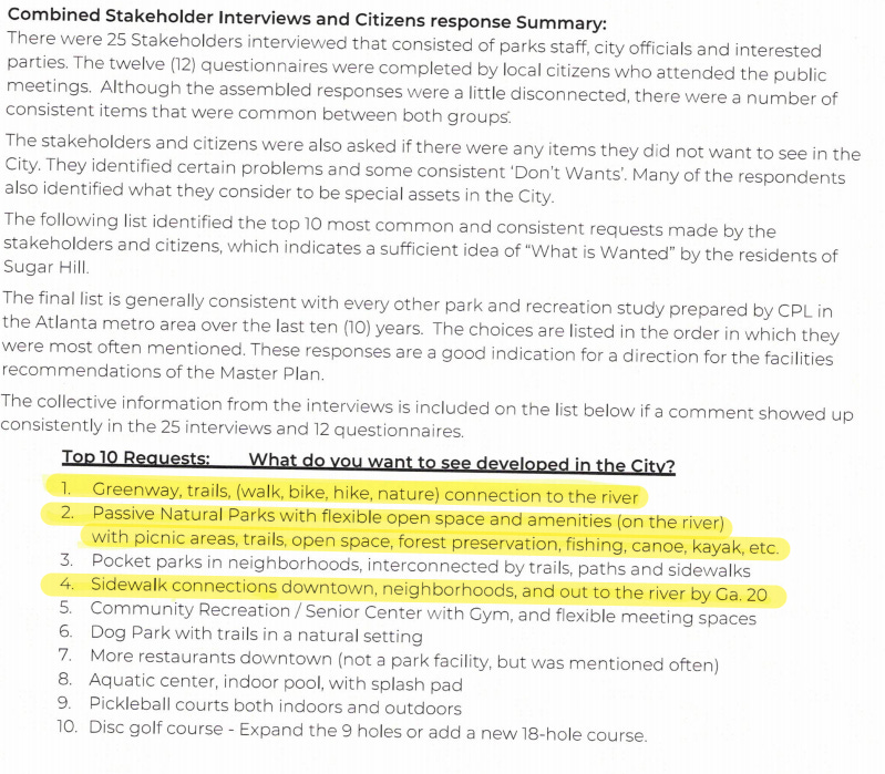
Importantly, the draft of the Parks, Recreation and Greenspace Master Plan indicates the most in demand park type in the city are passive parks.
It would also take out a serious safety concern should the emergency spillway of Lake Lanier ever be engaged. A good discussion on that topic can be found in this article in the North Gwinnett Voice discussing the construction of Lake Lanier in the 1950s.
Gary Pirkle Park should be converted to a passive park over time once the city purchases and constructs a new active park in a proper location that doesn’t present the long-term safety and unknown financial liability that currently exists. This also aligns with the community’s desire for more passive park space in the city, connection to the Chattahoochee River along with other opportunities to expand recreational opportunities in the city.